BLUEPEACE blog

SEA LEVEL REFUGEES

By Johannes Luetz

There could be 200 million “climate change refugees” by 2050, according to a new policy paper (1) by the International Organization for Migration (IOM). Aside from islands in the South Pacific and low-lying coastal countries like Bangladesh, the problem is also likely to hit home in the Maldives, where President Mohamed Nasheed recently announced the creation of a sovereign wealth fund to buy new land elsewhere should rising sea levels inundate the country and necessitate a forced relocation. There is no denying it: “climate change refugees” have joined the list of looming climate change issues, and the problem is increasingly filtering through to the public.(2)

img_2997.jpg
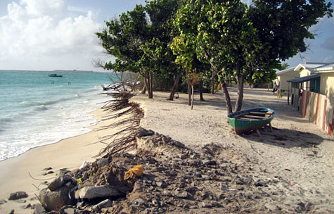
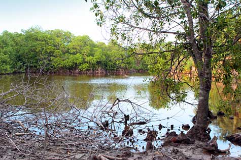
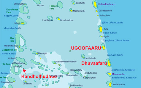
Erosion is a big problem on the recently settled island of Dhuvaafaru. According to local eyewitnesses, in one week (May 2009) the west monsoon surges claimed 20 feet of land. Islanders have piled up rubble in an attempt to slow down the advancing ocean and protect their houses.

A few weeks ago I came to the Maldives to orient myself about the looming “climate change refugee” problem as part of a PhD project. (3) During a brief visit I enjoyed numerous positive encounters with policy makers, NGO workers, and local atoll islanders. Time and space constrain me to limit my observations to three challenges and possible remedies. These snapshot impressions may fail to be comprehensive but I hope that they can nonetheless serve as useful guiderails on the country’s path to a friendly and feasible future:

img_3000.jpg
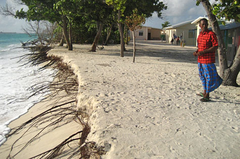
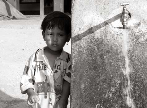
Easa Mohamed (52) moved to Dhuvaafaru on 10 December 2008. He is concerned that the island’s bad erosion problem could soon force him to abandon his brandnew house (pictured on the far right).

img_3002.jpg
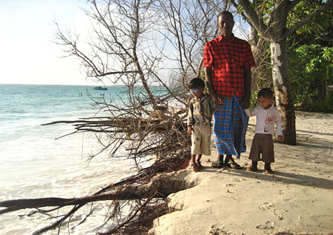
Easa Mohamed (52) with two of his grandchildren, Mohamed Yamin (left) and Abdulla Rizan (right). He says unless the coastline is reinforced, next year’s west monsoon surges are bound to wash his house into the sea.

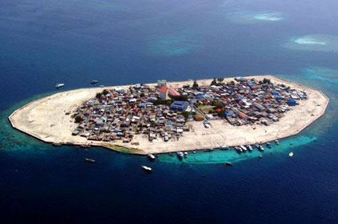
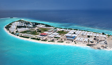
1. BUILD UP : My brief visit to the recently resettled island of Dhuvaafaru reinforced my conviction that “elevated islands” are critical if infrastructural investments are to be successfully protected. Let me explain. After Kandholudhoo was devastated and rendered uninhabitable by the 2004 Indian Ocean Tsunami, millions of dollars were pumped into the blueprint development of Dhuvaafaru: thousands of trees were felled; hundreds of houses were constructed; community centres were built; health facilities were established; schools were designed; state-of-the-art equipment was put in place (including high-tech desalination plants and 24/7 power generators). Altogether multiple millions of dollars were invested to facilitate the resettlement of 4,000 tsunami relocatees to their new island home. In the face of accelerating sea level rise and worsening erosion these infrastructural investments are now increasingly at stake. While erosion has always been part and parcel of daily life for thousands of islanders the world over, climate change and related rises in sea level have begun to increase and intensify land loss in many parts of the world. (4) The Maldives is no exception. Once infrastructure is locked in place, it is too late to elevate an island to a higher baseline level. Only time will tell how many years remain until low-lying Dhuvaafaru succumbs to the nibbling sea. I offer that any effort to maximise on time and money should see low-lying islands elevated first, and costly infrastructure built up second. This will not prevent sea level from rising, but it will buy more time. (Hulhumalé is a case in point.)

img_2956.jpg
Brandnew diesel generators on the Island of Dhuvaafaru. This power house generates continuous (24/7) power supply and burns more than 1,000 litres of diesel fuel each day (i.e., 33,000 litres per month, 396,000 litres per year). CO2 emissions on that order of magnitude represent a significant obstacle to the Maldives’ ambitious plan to become the world’s first carbon neutral country.

img_3010.jpg
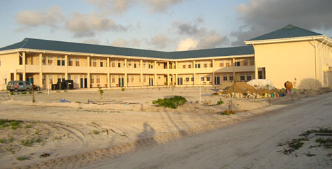
Expensive infrastructural investments like these brandnew buildings on Dhuvaafaru are increasingly threatened by sea level rise and erosion. Once elaborate infrastructure is locked in place, it is too late to raise an island to a safer (“elevated”) height. Advance safety measures generally represent a large saving in terms of avoided losses and reconstruction costs, and should be viewed as a way of lowering the overall costs of economic development. Prioritising preparedness protects progress.

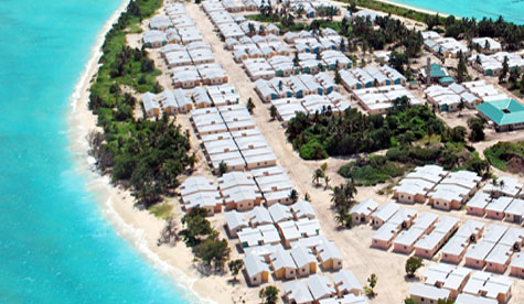
2. TEAM UP : Despite some valid criticism levelled at Dhuvaafaru by individual islanders about their new houses or town layout (5), in many ways the relocation of an entire island populace numbering thousands of people from Kandholudhoo to Dhuvaafaru can be regarded as a remarkable achievement. As I traversed the width and breadth of the newly populated island of Dhuvaafaru, I was thrilled to see that the demographic planners had evidently succeeded to maintain the cohesion of the entire island community. In fact, in the face of global climate change, rising seas, and the looming resettlement of millions of future “sea level refugees” (6) to new homelands, I was impressed to see that the island community had been corporately resettled from one place to another rather than dissolved and absorbed into the social fabric of multiple other island communities. On the contrary, its integrity and societal unity had been successfully safeguarded and maintained! And it showed. Despite the brandnew locality everybody already seemed to know everybody else — the harmony and familiarity between the islanders was clearly evident. This fact in itself makes Dhuvaafaru a fascinating case study. In the event that a doomsday sea-level-rise-scenario should eventually render small island states uninhabitable, refugee resettlement plans should invariably include measures to ensure the ongoing sovereignty, unity, integrity and cultural identity of affected island communities. This is a key success factor, and Dhuvaafaru is a case in point.

img_2869.jpg
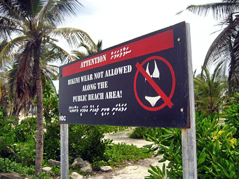
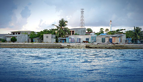
“Bikini wear not allowed along the public beach area!” A big notice-board on Hulhumalé advocates proper beach wear. Similar signs could advocate proper trash disposal and environmental protection.

3. CLEAN UP : A somewhat more sobering impression was the amount of trash I observed in parts of the country. While travelling by speedboat I watched as half a dozen local passengers threw nonbiodegradable trash overboard (plastic bottles, Milo drink containers, plastic wrappers, etc). Nonbiodegradable waste — as the word suggests — is “non”biodegradable, i.e., it does not decay in the water. Instead, nonbiodegradable waste floats forever in the sea, tossed to and fro by the ocean currents, until it finally washes up on some shore. And it showed. In numerous places I was saddened to see the natural beauty of the Maldives tarnished by raw garbage, either bobbing up and down, floating in turquoise waters, or washed up on formerly pristine beaches. On the island of Hulhumalé I spotted a big bill-board which advocates proper beach wear: “Bikini wear not allowed along the public beach area!” I thought to myself that similar signs could advocate proper trash disposal and environmental protection. Moreover, additional rubbish bins could be set up to help keep the Maldives clean (I repeatedly found myself hard-pressed to find a rubbish bin where to discard my emptied water bottles, etc). Why is cleanliness important? Simple. A rising ocean progressively reduces the amount of available land. As time goes by, more and more people will share less and less land. Hence it is pivotal to make the best possible use of the available land and maintain the highest possible hygienic standards for the wellbeing of both people and biosphere.

img_2894.jpg

img_2890.jpg
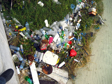
Garbage washed up on the shores of Hulhumalé. Nonbiodegradable waste does not decay in the water.

In summary I offer one final point. Efforts to protect the biosphere are usually conceptualised as an additional cost. In fact, one of the principal arguments often used to justify a lack of progress in environmental protection is that developing countries have other priorities, e.g. economic development, and cannot afford the additional costs of protective measures. (7) I would like to volunteer a contrasting view. Investment in safety measures and environmental protection generally represents a large saving in terms of avoided losses and reconstruction costs, and should be viewed as a way of lowering the overall costs of economic development. In the short run, building up “elevated islands” prior to their infrastructural development costs additional time and money. In the long run, however, such protective measures will save more money (and buy more time!) than their initial investment cost. Safety measures and environmental protection are an investment, not a cost.


Johannes Luetz is the lead author of World Vision’s Asia Pacific Disaster Report ‘Planet Prepare’. He is currently conducting a research on ‘Climate Change Migration – Resettling Island Communities Displaced by Sea Level Rises’.

You can contact the author at planetprepare@gmail.com
All photographs by Johannes Luetz

NOTES

(1) http://www.iom.int/jahia/webdav/shared/shared/mainsite/policy_and_research/policy_documents/policy_brief.pdf

(2) http://www.nytimes.com/2009/05/29/world/29refugees.html

(3) Sea Level Refugees: People displaced by rising sea levels, the topic of my PhD research (“Sea Level Refugees: Opportunities And Success Factors For Controlled Climate Change Migration – Lessons From Present-Day Small Island Resettlements”). Contact me by e-mail for information on my PhD research: planetprepare@gmail.com

(4) See World Vision Asia Pacific Disaster Report “Planet Prepare” for more information on relocating coastal communities, including in Papua New Guinea and Bangladesh (124 pages, 8MB): http://www.wvasiapacific.org/downloads/PlanetPrepare_LowRes.pdf

(5) In a number of ways the houses on Dhuvaafaru reminded me of the tsunami survivor villages I visited some time ago along the western coast of Aceh Province, Indonesia. It is perhaps not surprising that such villages, often built by the international development community under significant time pressure, are prone to similar weaknesses. Criticism levelled at Dhuvaafaru during my visit (I repeatedly had to stress that I was not a representative of the IFRC) commonly addressed the following points: Many house entrances were designed to face west, which makes houses more vulnerable to sand, wind and rain entering in. Also some cultural and lifestyle needs were not properly taken into consideration such as fishing community-specific felt needs or the absence of corner shops (to buy basic household items people now have to walk long distances), etc. A better consultative process at grassroots level could have identified such potential flaws prior to the towns construction. This is especially important in the case of a slow-onset disaster like rising sea levels which allow more time for advance planning and preparation.

(6) Numerous studies have attempted to estimate the number of future climate exiles. One voice makes the point clear: “When we talk about a one metre rise in global sea level we are also talking about 500 million people who are going to have to look for new homes. So far we don’t have any instruments to manage this.” (Prof. Dr. Hans Joachim Schellnhuber, Director Potsdam Institute for Climate Impact Research, Chairman German Advisory Council on Global Change (WBGU), Senior Advisor to the German Government)

(7) See also Disaster Risk Reduction Global Assessment Report @ http://www.preventionweb.net/english/hyogo/gar/report/index.php

Comments (5)

USING WATER POSITIVELY FOR SUSTAINABLE DEVELOPMENT

Today is World Water Day. Following an initiative at the United Nations Conference on Environment and Development at Rio de Janeiro in 1992, the UN General Assembly passed a resolution to mark March 22 of each year as the World Day for Water. The UN is marking International Decade for Action: “Water for Life” 2005-2015, calling for global action on water and water-related issues, aiming to reduce poverty and increase access to better health and sanitation.

child.jpg
A child stands near a water tap used for collecting water in a village in Nepal. The UN is marking 2005-2015 as Water for Life decade.

Bluepeace is concerned that, as we mark the Water Day, several islands of Maldives are plagued with a shortage of drinking water, as reported by Minivan News.

“I am very upset with the government because we need water,” said 42-year old Jameela Aboobakuru from Gaafaru. “We ran out of water, so we borrowed water from our brother. When he ran out of water we started buying bottled water imported from Male’.”

She said her 12-member family was spending US$22 a day to buy bottled water for drinking and cooking; their daily income, she added, was only US$26.

On another island, Gulhi, Ahmed Ibrahim, the island office assistant director, said islanders had been importing bottles water from the capital as well as in jerry cans.

“They are getting water somehow,” he said, “but the island needs a permanent solution to this problem like piped desalinated water.”

plastic-water-tanks.jpg

After the tsunami of December 2004, several aid organizations provided islands with plastic water tanks. In addition, UNICEF provided 23 desalination plants, each costing US $ 70,000 to islands affected by the tsunami. Despite community water tanks found in abundance in islands, there is no national mechanism to prepare for a dry spell or a shortage of drinking water. Some desalination plants donated to islands by aid agencies are not being used or are out of order. Bluepeace calls for a national policy and mechanism to deal with such a crisis and ensure that the people have access to safe drinking water throughout the year.

Bluepeace had in the past raised the issue of groundwater contamination, caused in most cases by untreated sewage seeping into the groundwater. This is a problem in the capital Male’ — where approximately one-third of the population lives — because of the poor design of the sewerage system. In Male’, contaminated groundwater is used by some households for washing dishes and clothes, while a few households use groundwater for bathing as piped desalinated water is too expensive. The use of septic tanks and primitive sewerage systems in other islands cause the effluent to sink into the ground, leading to contamination of the groundwater. Unlike Malé, in the other islands, majority of the households use groundwater for washing clothes, dishes and for bathing, as piped desalinated water is not available. When rainwater is depleted, during dry spells, the people drink groundwater in several islands. In fact, 25% of the people of the Maldives depend on groundwater for drinking according to State of the Environment Report 2002.

mangroves.jpg
Mangroves suck up more carbon dioxide per unit area than sea phytoplankton, a key factor in global warming. Mangroves are not adequately protected in the Maldives.

On World Water Day, Bluepeace reiterates its call for preservation of freshwater ecosystems and mangroves in the Maldives. Such ecosystems are home to a number of species of plants and organisms and are important to preserve biodiversity. As Maldives embarks on a bold and ambitious plan to be carbon-neutral within 10 years, the role of mangroves in absorbing carbon dioxide should not be overlooked. Mangroves in the Maldives also protect the coastlines from erosion, and absorbed the lethal power of the tsunami in 2004, acting as a layer of protection. Atoll mangroves in the Maldives are threatened by development projects, reclamation plans, garbage disposal and introduction of alien species, among other issues.

On World Water Day, the government, media, civil society organisations, aid agencies, and other stakeholders should be thinking of ways to collaborate during the Water for Life Decade to make water a resource for poverty reduction, improving healthcare and preservation of our precious environment.

Comments (2)

DHUVAAFARU: ONE OF THE MOST VULNERABLE ISLANDS TO CLIMATE CHANGE

When the fishermen of Kandholhudhoo in Raa Atoll returned to their island on 26 December 2004, they were shocked to see a destruction that was difficult to describe. Debris from collapsed houses and destroyed buildings were scattered everywhere. They had not seen the deadly wave of destruction that hit the island in the morning. Most of those who witnessed the horror, those who frantically swam for their lives in the waters, had already left, in boats from other islands which had arrived for rescue. Clueless about what had hit their island, and the whereabouts of their family members, the fishermen set out in their boats, searching for loved ones.

map.jpg

This was how life began for the people of Kandholhudhoo as internally displaced persons (IDPs), scattered in five different inhabited islands of Raa Atoll, living in temporary shelters. They would stay in makeshift tents for four years, till December 2008, when they were resettled in Dhuvaafaru, an uninhabited island, which was built from scratch by the International Federation of Red Cross and Red Crescent Societies (IFRC).

Kandholhudhoo

kandholhudhoo.jpg
In Kandholhudhoo houses were located within ten feet from the sea, and without the protection of the house reef, the island lay like a ticking bomb.

Among the islands of Raa Atoll, only Kandholhudhoo, located on the western edge of the atoll, was badly hit by the Indian Ocean tsunami of December 2004. However, the island had suffered monsoon flooding and swells even prior to the tsunami. Kandholhudhoo was an extreme case of population congestion, with more than 3,000 people living in a tiny speck of land with only 150 meters in width and a land area of merely 4.4 hectares. Life in the island was inhospitable even back in 1990s. However, the people refused to settle elsewhere, because of the island’s proximity to good fishing grounds and various other socioeconomic factors. An economy based on traditional fishery and sea cucumber fishery thrived on the island. Young fishermen often scuba dived recklessly, surfacing too fast with sea cucumbers, impatient to go for another dive to pick more sea cucumbers from depths below. However, as the lure of a quick buck increased the cases of decompression sickness, life went on in Kandholhudhoo, and people continued to walk in the island’s narrow lanes – some barely enough for a person to walk, and some too narrow for a coffin to be carried – and new buildings sprouted from the income earned through fishery.

Reclamation

kandholhudhoo-aerial.jpg
The large population pressure had led to the reclamation of the coastal area of Kandholhudhoo in all directions beyond the local reef, making the island more vulnerable.

The island became first vulnerable to monsoon floods and swells due to a combination of factors including a reclaimed shoreline and a mined reef. To find a temporary solution to the high population pressure on this island, the previous government gave in to the demands of the islanders by allowing the reclamation of the coastal area in all directions beyond the local reef, known as the “house reef”. Houses were located within ten feet from the sea, and without the protection of the house reef, the island lay like a ticking bomb. The occasional swells and flooding could have been warnings of an inevitable doom.

Dhuvaafaru

Dhuvaafaru, literally meaning “running reef” in local language Dhivehi, was an uninhabited island in the eastern edge of Raa Atoll. In reality the reef is not moving but the island has got very dynamic beaches and the shape of the island changes frequently.  While the reef remains in its original location, the shifting beaches and variations in the shape of the island during different seasons must have led to local fishermen to name the island as a moving reef.

dhuvaafaru-aerial-3.jpg
Dhuvaafaru as an uninhabited island in the eastern edge of Raa Atoll.

Seasonal variations in the shape of beaches and shoreline are not a new phenomenon in the Maldives. In fact, in most islands of the Maldives, the forces of erosion and deposition, along with variations in ocean currents and wind, based on the Monsoon, causes the location of beaches to shift. The location of a large white sandy beach during northeast monsoon may turn into a lagoon in the southwest monsoon, while the beach is formed in another part of the island. In Dhuvaafaru, the forces of nature were at work more intensely, making the island very dynamic.

Bad Choice

Dhuvaafaru project has been the largest single post-tsunami reconstruction project in the Maldives and one of the biggest in the IFRC’s history by developing an island community on 49 hectares of low-lying uninhabited coral island in the Maldives. The IFRC has built 600 new houses and other amenities, using donations from the American, Finnish, and German Red Cross societies, and at a cost of 35.6 million Swiss francs.

However, proper consultation was not made with the island community of Kandholhudhoo before the decision was made to resettle them in Dhuvaafaru. Officials of the former government had a minimal consultation with the island community while the people were traumatized by the tsunami. Moreover, proper studies were not made on the topography and geomorphology of the island before it was selected.

Dhuvaafaru is one of the lowest islands in Raa Atoll with a height of less than a meter. Moreover, not less than one third of a meter from the top soil of Dhuvaaafaru has been removed in leveling the land surface, further lowering the island’s height during the construction of infrastructure.

dhuvaafaru-aerial-1.jpg
Dhuvaafaru is one of the lowest islands in Raa Atoll with a height of less than a meter above sea level.

At the end of her official visit to Maldives (18-25 February 2009), the United Nations Human Rights Council’s Special Rapporteur on Adequate Housing, Ms. Raquel Rolnik, pointed out a number of concerns, such as allotment of resources by some international donors and their administration by the Maldivian authorities, which was not done as competent as it could have been. “In the new resettlement sites that I visited, I detected a lack of participation in the decision making process concerning relocation, the design of the new houses, and the infrastructure, which resulted in new structures that were not always compatible with the livelihood of the communities”.

Dhuvaafaru is an example of the type of new resettlement where there was not sufficient community participation in the decision-making process. The traumatized people were in need of a new home, and they were willing to go anywhere. The government officials, by choosing Dhuvaafaru, made an impractical decision as Dhuvaafaru is a relatively small island and would not cater to an expanding population. The people of Kandholhudhoo, after suffering from population congestion and land scarcity, would encounter the same problems within a few decades in Dhuvaafaru. Some government officials and even a few islanders seemed to envision a solution in the pristine lagoon of Dhuvaafaru. They were hoping to reclaim the lagoon and find new land, even though such an expansion would make the island even more vulnerable. Land reclamation had been one of the favoured solutions of the previous government, whether it was to ease population congestion, for developing new resorts, or even for waste management. No lessons seem to have been learned from the example of Kandholhudhoo.

Bleak Future

The United Nations Intergovernmental Panel on Climate Change (IPCC) has recently projected in its latest report a rise of the sea level worldwide by two feet by 2100 as a result of melting ice sheets and the expansion of the sea by warming seawater. If the IPCC projection is accurate, Dhuvaafaru would be among the first islands to be affected by rising global sea level. Dhuvaafaru is promoted as a ‘safer island’. It is ironic that such a comparatively low island was selected to house tsunami refugees.

dhuvaafaru-aerial-2.jpg

There is historical evidence that people lived in Dhuvaafaru some 200 or 300 years ago. In the famous tale of Mohamed (Bodu) Thakurufaanu who saved the Maldives from Portuguese in 16th century, his compatriot Dhandehelu hails from Dhuvaafaru. Elderly people from Kandholhudhoo claim their ancestors lived in Dhuvaafaru. Some even say the tombstones of their forefathers had inscriptions with references tracing the origins of the family to Dhuvaafaru.

Dhuvaafaru was abandoned by its last inhabitants due to erosion. The people of the Maldives had always lived at the mercy of the forces of wind, water, and salt. Erosion is not a new phenomenon. Historians and geographers, who had visited these islands centuries ago, had chronicled the migration of the island communities from one island to the other because severe erosion, abandoning islands and taking with them their belongings including even trees. This had been first documented by Arab geographers Abu Zayd of Siraf in 890 A.D. and Al Biruni in 1030 A.D. Hence, it is probable that the people living in Dhuvaafaru left the island and settled in Kandholhudhoo due to its proximity to rich fishing grounds.

If that had been the case, history seems to be on a reversal, as the descendants of those people return to Dhuvaafaru, not because of erosion, but after being refugees of the tsunami triggered by a submarine earthquake off the coast of Sumatra in December 2004. It will be an irony of history, if the descendants of the current settlers are forced to abandon Dhuvaafaru, due to climate change, erosion and rising sea levels in the not too distant future.

Comments (14)

« Previous Page« Previous entries « Previous Page · Next Page » Next entries »Next Page »